State of Leonida
GTA 6 interactive map
48/48 SHOWN
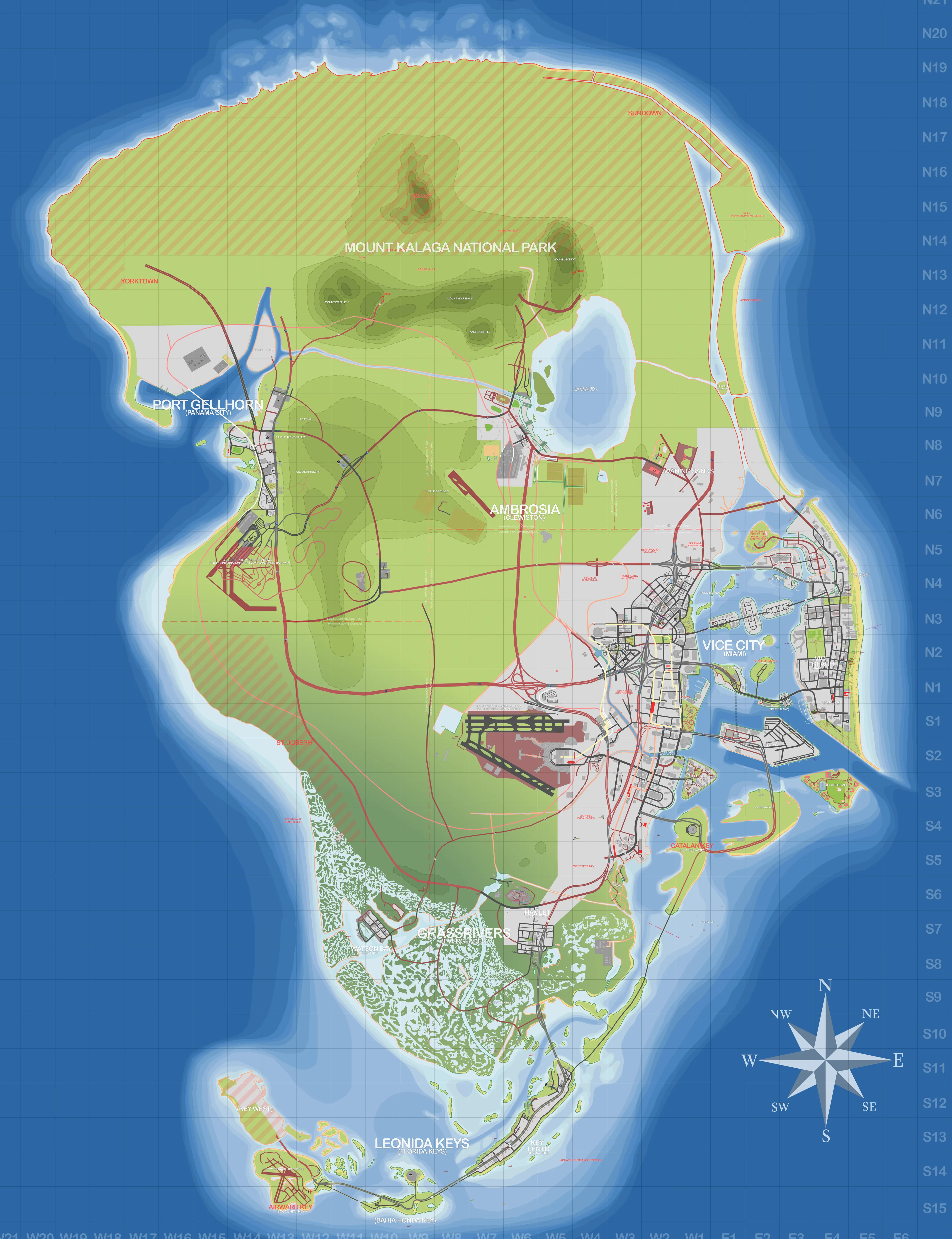
Map: YANIS GTA VI Community Map v13 · stateofleonida.net
What locations are on the GTA 6 map?
48 locations across the state of Leonida are confirmed so far — 40 landmarks, 5 activities, 3 shops — spread over 7 counties and regions. Community analysis of the trailers puts the playable map at roughly 125 km² of land, about twice the size of GTA V's, with no loading screens between regions. Everything below was identified from Rockstar's official trailers and screenshots; the map fills in as more is revealed before the November 19, 2026 launch.
Vice-Dale County
29- Ocean BeachLandmark · Vice CityArt-deco beachfront district on the barrier island — the classic Vice City postcard from Trailer 1.
- Washington BeachLandmark · Vice CityMid-beach stretch of the barrier island north of Ocean Beach, returning from the original Vice City.
- Vice BeachActivity · Vice CityThe beach party scenes from the trailers — jet skis, muscle beach and crowds.
- Little CubaLandmark · Vice CityCuban quarter west of downtown, confirmed by street signage in trailer footage.
- La PerleLandmark · Vice CityReturning neighborhood north of Little Cuba.
- Vice City International AirportLandmark · Vice CityThe state's main airport, southwest of downtown.
- Ammu-NationShop · Vice CityThe series' weapon chain is certain to return — exact storefronts TBA at launch.
- Shore Court GarageShop · Ocean BeachPersonal garage included with the Vintage Vice City Pack pre-order bonus.
- Vice CityLandmarkLeonida's Miami-inspired metropolis and the heart of the game — officially confirmed by Rockstar.
- DowntownLandmark · Vice CityThe high-rise core of Vice City — the skyline backdrop throughout both trailers.
- StockyardLandmark · Vice CityWarehouse and arts district north of downtown, Vice City's take on Wynwood.
- CrosstownLandmark · Vice CityInner-city district between Stockyard and downtown.
- RockridgeLandmark · Vice CityRiverside district on Vice City's west side.
- BaysideLandmark · Vice CityBayfront strip east of downtown — marinas, parks and the causeway approaches.
- Vice RiverLandmark · Vice CityThe working river winding through the city's south side, lined with docks and boatyards.
- Port VCLandmark · Vice CityThe city's cargo and cruise port on the bay islands, Vice City's Port of Miami.
- TequestaLandmark · Vice CityHigh-rise financial district south of the river — Vice City's Brickell.
- Tequesta KeyLandmark · Vice CityCompact island enclave just off Tequesta's waterfront.
- BohemiaLandmark · Vice CityVice City's design district north of Downtown — the map's counterpart to Miami's Design District.
- Tisha-WockaLandmark · Vice CityInland northern neighborhood of Vice City, standing in for Opa-locka.
- BelvilleLandmark · Vice CityInland neighborhood west of the city core, mapped to Brownsville.
- EkanfinakaLandmark · Vice CityInland Vice City neighborhood east of Belville — the map's Allapattah.
- Leaf Links Golf ClubActivity · Vice BeachIsland golf club in the bay off Vice Beach, returning to the series from the original Vice City.
- SouthsideLandmark · Vice CityLeafy southern suburb of Vice City, standing in for Coral Gables.
- Peacock BayLandmark · Vice CityWaterfront neighborhood on the bay south of Tequesta — Vice City's Coconut Grove.
- Catalan KeyLandmarkBarrier island southeast of the city, reached by causeway — the map's Key Biscayne.
- HamletLandmarkFarm-belt town where the suburban sprawl gives way to the Grassrivers wetlands.
- Rialto IslandsLandmark · Vice CityChain of artificial residential islands in Catalan Bay, named on screen in An Extended Look.
- Starfish IslandLandmark · Vice BeachOval man-made island of waterfront estates south of the Rialto Islands, confirmed by a road sign.
Mariana County
5- GrassriversActivityEverglades-style wetlands — airboats, gators and the Mud Club scene from Trailer 2.
- Watson BayLandmarkSleepy gulf-side bay community in the southwest.
- Paradise GarageShop · Watson BayDedicated garage included with the Ultimate Edition, located in Watson Bay.
- Key LentoLandmark · Leonida KeysFirst island of the Keys chain — bridge diving in Trailer 2.
- Leonida KeysLandmark · Leonida KeysIsland chain arcing off the southern tip — boats, bars and hurricanes.
Mount Kalaga
4- Mount Kalaga National ParkLandmarkForested highlands in the north — rock climbing shown in Trailer 2.
- Domed HillsLandmarkRolling hill range inside Mount Kalaga National Park.
- RedhillLandmarkNamed area on the western edge of the Mount Kalaga highlands.
- Fairyland ForestLandmarkWoodland tract in the northeast of Mount Kalaga National Park.
Kelly County
3- Port GellhornLandmarkFaded gulf-coast panhandle town — strip malls, motels and the biker scene.
- Gellhorn International RacewayActivityRace complex south of Port Gellhorn — Leonida's answer to Sebring International Raceway.
- Draper IslandLandmark · Port GellhornIndustrial island in the bay off Port Gellhorn.
State of Leonida
3- YorktownLandmarkSmall town on the northwest coast, west of the national park.
- SundownLandmarkNamed area on the far northeastern coast of the state.
- SERALandmarkAtlantic-coast launch complex of SERA, the in-game space agency — mapped to the Kennedy Space Center.
Leonard County
2- Waning SandsLandmarkCoastal area north of Vice City in Leonard County.
- North BeachesLandmarkThe barrier-island beach strip running north from Vice Beach along the Atlantic coast.
Ambrosia County
2- AmbrosiaLandmarkIndustrial town in the northeast — sugar refinery smokestacks appear in Trailer 2.
- Lake LeonidaActivityThe state's big inland lake — fishing and airboat footage points here.
Map positions follow the GTA VI Mapping community's YANIS map. For what to do in these places, read getting started in Leonida or the hidden stash locations guide.